
Alice C. Linsley
Genesis chapter 7 speaks of water levels so high that they covered all the mountains under the heavens (7:19). If this is hyperbole it doesn’t matter where Noah was living. However, if this is an account from Noah’s perspective, it would be helpful to know where Noah lived. There is only one place on earth that is claimed by the natives to be Noah’s homeland and that is Bor’Nu (Land of Noah) in the region of Lake Chad.
A black mahogany dugout was excavated in Bornu in 1987. The 8000-year Dufuna dugout (shown below) was buried at a depth of 16 feet under clays and sands whose alternating sequence showed evidence of deposition in standing and flowing water.

According to Peter Breunig (University of Frankfurt, Germany), “The bow and stern are both carefully worked to points, giving the boat a notably more elegant form”, compared to “the dugout made of conifer wood from Pesse in the Netherlands, whose blunt ends and thick sides seem crude”. Judging by stylistic sophistication, Breunig reasons that, “It is highly probable that the Dufuna boat does not represent the beginning of a tradition, but had already undergone a long development, and that the origins of water transport in Africa lie even further back in time.”
The Lake Chad Basin is the largest inland drainage system in Central Africa, and it is surrounded by mountains. Between 41,000 and 2,300 years ago it experienced four high water periods. The period has been called the African Humid Period, and the African Aqualithic. The latter term was coined by the British archaeologist John Sutton (Journal of Africa History 1974; Antiquity 1977). Noah would have lived during the last high water period. Around 4000 BC, when Noah would have lived, Lake Chad is estimated to have covered an area of 248,548 miles (400,000 km).
During the African Aqualithic much of the Sahara was wet and the waters systems along the African rift interconnected. It was possible to travel by small boats between the Nile and Lake Chad. This explains the common plant and animal species found in both water systems.

The gray areas on this map show the ancient water ways. The solid black line shows the rift line. Lake Chad is where the countries of Niger, Chad, Nigeria and Cameroon meet.
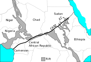
The map shows the African Sheer Zone.
From Noah's perspective in an ark floating on Lake Chad the waters would have appeared to cover all the ridges that would be visible in drier periods. This elevation data indicates the highest ridges visible to Noah would have had an elevation of about 1083 feet (330 meters). With higher water levels these ridges would have appeared to be submerged.


.jpg)


No comments:
Post a Comment